
Page 238 - Kỷ yếu hội thảo khoa học lần thứ 12 - Công nghệ thông tin và Ứng dụng trong các lĩnh vực (CITA 2023)
P. 238
222
Indoor map data acquisition is about the methods, sensors, media, and platforms
that are used to collect raw data of indoor environments [5]. Commercial mobile
indoor mapping systems can be grouped into different categories based on how the
measurement device is set up: handheld; backpack and trolley [6] for indoor
environments or human-based; wheel-based; boat-based; and sledge-based [7] for
outdoor environments. The sensors that are used for 2D/3D indoor environment
mapping usually include light detection and ranging (LiDAR), terrestrial laser
scanner, RGB-D camera, inertial measurement units (IMUs), etc. Di Stefano et al. [7]
give a detailed review of mobile laser scanning systems used in both outdoor and
indoor environments, divided into five application domains: the built and urban
environment, cultural heritage and archaeology, the underground environment,
environmental monitoring, forestry, and agriculture. Virtanen et al. [8] show an
approach for creating virtual indoor environments based on photogrammetry/image,
terrestrial laser scanning, and depth camera, combined with game engine to assess the
quality and usability of geometric indoor models.
Geographic information systems (GIS), which are designed to collect, organize,
manage, analyze, and visualize spatial data, can be used to study indoor modelling
[4]. Indoor cartography or indoor map representation provide simplifications of the
physical spaces based on indoor modelling and applications, as well as visualization.
A systematic review focused on the use of GIS in the analysis of indoor spaces was
presented in [9]. Building information modeling (BIM), which aims to develop a
method to manage important building design and project data in digital format
-cycle [10], and 3D city models, which aim to represent
urban environments with three-dimensional geometries of buildings and structures
[11], are widely applied to indoor space modelling [12, 13]. Recently, indoor space
modelling has used augmented reality (AR) technologies for indoor scenes; and,
the use of AR devices, such as the Microsoft HoloLens, now improves the indoor
navigation experience [14] [16].
3 Our approach
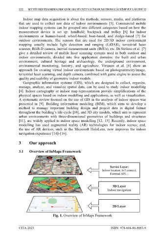
3.1 Overview of InMaps Framework
Service Layer:
Indoor location, IoT connect,
3D Layer
Indoor navigation
2D Layer
Fig. 1. Overview of InMaps Framework
CITA 2023 ISBN: 978-604-80-8083-9