
Page 244 - Kỷ yếu hội thảo khoa học lần thứ 12 - Công nghệ thông tin và Ứng dụng trong các lĩnh vực (CITA 2023)
P. 244
228
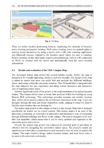
Fig. 6. 3D Maps
Then, we utilize location positioning features, employing two methods of location:
active locating and passive locating. With active locating, users are granted rights to
actively locate themselves by using a device with a QR code scanning application,
and Bluetooth beacons respond to the location signal where the user is standing.
Passive locating, on the other hand, requires user permission, such as a 4G connection
or Wi-Fi, to connect with the server and automatically send the user's location
information.
4.3 Results and evaluation of the VKU Campus Map
The developed indoor map project has several notable results. Firstly, the map is
designed to be visually appealing, intuitive, and user-friendly. The design of the map
is aimed to ensure that users can easily find and navigate the different buildings,
floors, and rooms within the university premises. The 3D model that is integrated into
the map enhances the user experience, providing a more immersive and interactive
way of exploring indoor space.
Another significant result of the project is the implementation of an indoor location
feature. This feature allows users to locate their position within the building by using
Beacon BLE technology. This technology provides accurate and reliable location
data, which can be used to enhance the overall user experience of the map. Users can
navigate through the map and locate themselves easily, making it easier for them to
find the exact location they are looking for.
The indoor map project is also unique in that it is like Google Maps but is designed
specifically for indoor use in a local context. This feature makes it an asset to the
university community as it provides an interactive and informative way of navigating
through different buildings and floors of the campus. The map is designed to be scal-
able and adaptable, which means that it can be easily updated and expanded as the
university grows and evolves.
Overall, the indoor map project has achieved its intended goal of providing an
effective tool for navigating the university's indoor space. The project's results are
significant as it provides a comprehensive and interactive way for users to explore the
campus. The map's intuitive design, indoor location feature, and local focus make it
an asset to the university community.
CITA 2023 ISBN: 978-604-80-8083-9